
Canons and Grasslands
2013 brings with it new opportunities in Birding and Avian Photography as well as my anticipation of spring wildflowers to arrive in a few short months along with warmer and longer days to explore my surroundings. This past weekend brought a gathering of old friends; I, Eric Gerber and Elmer Schweitzer, to spend a day or two exploring the local area. I decided to keep our adventure relative to a circumference of a 15 to 20 mile radius from my home south of Gettysburg Pennsylvania, near the Mason Dixon Line, on a trip for wintering Raptors who reside within the area grassland habitats. I would also discover a new wetland area less than 10 minutes from my home, right under my nose, that I had no idea existed. What a wonderful find and the upcoming spring will bring this place to life from the frozen habitat I found at present.
Union Mills Wetlands, Maryland
A casual search of the E-Bird database and maps brought this location to my attention just within the past week while I was looking at the observations by fellow birders for my area. It has been listed as a “Birding Hotspot” for a long time, but I never though to click the marker and check the observations by others for the location. The area is listed as the “Union Mills Wetlands” and is located just to the north of one of my favorite areas, the Kowomu Trail, just below the Pennsylvania state line near Union Mills Maryland. It’s a mixture of planted trees, woodlands and a large freshwater marsh. It is a protected area under the control of the Maryland Department of Natural Resources, bordered by a small dirt road that parallels its northern boundary with ample room to pull off to the side to set up a spotting scope or camera gear.
My initial exploration of the area alone Friday afternoon was rewarded by sightings of a flock of Eastern Bluebirds (7), Black-capped Chickadees (5), Tufted Titmouse (3), Hermit Thrush (1), ,Red Shouldered Hawk (1), Red-tailed Hawks (2) and a juvenile Coopers Hawk (pictured below) who posed for a few pictures without a care of my presence. I also observed include several species of sparrows. This is going to be a wonderful place for photography in the very early morning and later afternoon light…

Immature Coopers Hawk, Union Mills Wetlands
The Freedom Township Grasslands, Adams County, Pennsylvania
Eric Gerber made the commute from Middle River Maryland (a Baltimore suburb) bright and early Saturday morning to meet me at my home and then we would drive the short distance to Gettysburg and gather our friend Elmer Schweitzer for a day afield and the hunt for wintering raptors. Elmer is blessed to live with “Gal” friend Chris Arentz who owns a 300+ acre farm with prime birding habitat in the heart of the Freedom Township Grasslands just off Pumping Station Road and near the famous and historical Sachs covered bridge.
The Freedom Township Grasslands (open grasslands off of Pumping Station Road) is considered an “Important Bird Area” (IBA) by the Pennsylvania Audubon Society. The area is a vast expanse of native grasslands, dotted by farms and a few homes all dedicated to the preservation of the wildlife and grassland habitat. To the east of the area, and just west of the battlefield is the farm of the late president Dwight Eisenhower and itself contains a large expanse of land and natural preservation forming the Eisenhower National Historic Site.
These grasslands are a favorite location for wintering birds and raptors with enough variety to keep a birder or an avid bird photographer happy throughout a cold winter’s day. This area is the northernmost range of a number of southern birds, and the southernmost range of a number of northern species, and thus maintains long and diverse birding seasons that can offer wonderful surprises, photography and observations.
Years back, the area held a decent breeding population of the Loggerhead Shrike and a few can still be found there today. I had observed a single bird a few weeks back on a woodpile near and just west the Sachs Bridge. Looking back, and after doing a little more research, I found that during 1992, the shrike was confirmed nesting in the Freedom Township Grasslands. This nesting marked the first Pennsylvania confirmed nesting of this once extirpated species in 55 years. The shrike was confirmed nesting in Adams County between 1992 and 1999 with approximately 47 birds fledged. There has been no confirmed nesting of the shrike since 1999 however, individual birds have been observed.
Popular species for the area include the Upland Sandpiper, a listed Pennsylvania “Threatened species” and two listed Pennsylvania “Endangered Species”, the Dickcissel and Short-eared Owl (winter resident). This area also includes the listed Pennsylvania “Endangered” Least Shrew (a mammal) as well. Other species found on the grasslands include the Bobolink, Eastern Meadowlark, Grasshopper Sparrow, Savanna Sparrow and the Northern Harrier and several species of hawks.
This will mark the first year I have observed a Rough-legged hawk in this area sitting in an old tree, just east of the Arentz property. American kestrels abound and can be found sitting on the tops of utility poles, lines or in the tress along any of the routes in the area. A few years back, and during an invasion, Chris Arentz had as many as 42 Short-eared owls perched in a confer just a few feet from her home. They now are regular visitors, but not in such numbers, to a few of her trees and a woodpile behind her house. On this trip we observed Red-shouldered, Red Tail and Coopers Hawks along with one solitary Sharpie.
A new addition to the area has been plantings of Ring-necked pheasants (pictured below) as a reintroduction project by a local farmer/landowner. This bird was photographed on the Arentz property.

Ring-necked Pheasant, Freedom Township Grasslands
Marsh Creek and the Sachs Covered Bridge, Adams County, Pennsylvania
Marsh Creek and the Sachs Covered Bridge are within themselves a wonderful habitat area on the eastern edge of the grasslands. The woods to the north of Pumping Station Road along the creek and easily accessed from Scott Road, are home to variety of species including the Eastern Screech Owl and Barred Owl, both of which I have observed or heard in the near past. Woodpeckers including the Hairy, Red-bellied and the Downy are prevalent here year round along with numerous species of songbirds especially in the spring and summer. The creek holds waterfowl such as the Canada goose, Black Duck, Mallard and Wood Ducks.
To the south across Pumping Station road and towards the bridge along Waterworks road can be equally as productive for birds. I have observed both the Barred Owl and the Great Horned Owl in this area too, along with a very friendly and photogenic Green Heron earlier in 2012.
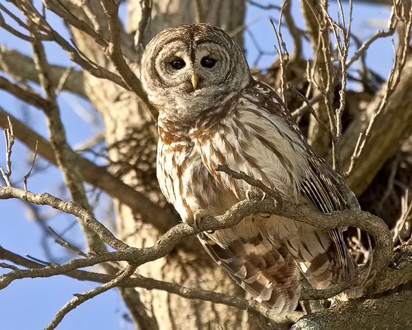
Barred Owl, Marsh Creek, Pennsylvania
The Sachs Covered Bridge is in itself worth a visit, but look out for “Ghosties”! According to the legend, three Confederate soldiers convicted of being spies were hanged from beams in the covered bridge and their bodies were discovered by Union soldiers patrolling the area. Their spirits were said to haunt the bridge, though other folks claimed they sometimes smelled General Lee smoking his pipe when they were standing on the bridge. The bridge is a popular destination for many of the Gettysburg area ghost tours and it’s not uncommon to visit around dusk or a little after to find a gathering of folks and their guide telling stories of “spooky” folklore!
This is the bridge that part of the Confederate Army of Northern Virginia used to begin their retreat to Virginia after the Battle of Gettysburg in July 1863. In 1938, the Pennsylvania Highway Department determined the Sachs Covered Bridge to be the most historic covered bridge in the state. It was closed to traffic in 1968 and listed in the National Register of Historic Places in 1980. On June 19, 1996, flood waters swept the bridge from its abutments and carried it approximately 100 yards downstream. Adams County rehabilitated the bridge, supported its trusses with steel beams, and raised the elevation 3 feet…

Sachs Covered Bridge (Winter) Adams County, Pennsylvania
Red Rock Road, Black Horse Tavern Road and Willoughby’s Run, Adams County, Pennsylvania
Heading east back towards the Battlefield and Gettysburg, you will come to the intersection of Black Horse Tavern road (left) and Red Rock road (right). Both roads follow the small stream, Willoughby’s Run and present a wonderful wetland and upland habitat for many species. A newly acquired parcel of land borders Willoughby’s Run, where Confederate General James Archer and 200 of his men were captured by General Solomon Meredith’s Iron Brigade.
Taking Black Horse Tavern road to the north will lead though farmlands, woodlands and small wetlands along the stream back towards Gettysburg and Route 116 (Fairfield Road). You can also access Willoughby Run Road for further exploration and reach the same highway just a little east of the Black Horse Tavern intersection. This is a popular route during late summer to find the many Cardinal flowers that bloom along the stream banks and a great place to observe and photograph hummingbirds. Wading birds and waterfowl also inhabit the stream along with many songbirds.
To the south, Red Rock road follows the stream to its confluence with Marsh Creek. There is an active Bald Eagle’s nest only a few hundred feet to the west of the road that presents wonderful opportunities for observation and photography. Other raptors are present, especially during the winter months. Pictured below is an American kestrel perched in an overhanging branch willing to pose for his photographer for a minute or two. These birds are very skittish and I was quite amazed to have him give me a gander for an extended period of time. I also observed a large flock of Eastern Bluebirds there just last week along with a stunning Red-tail Hawk. I guess he wasn’t hungry. Perhaps the Bald Eagle present kept the hawk at bay!
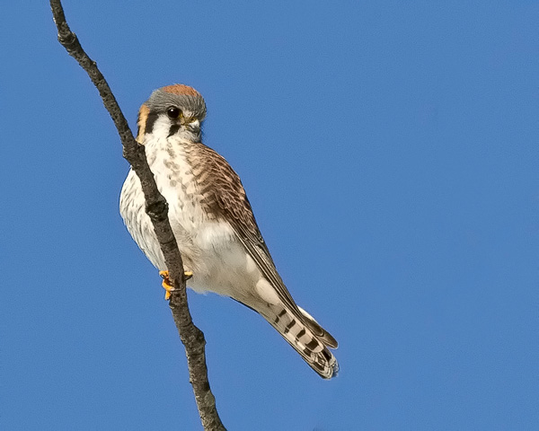
American Kestrel, Willoughby’s Run, Adams County, Pennsylvania
The Gettysburg National Battlefield and West Confederate Avenue, Gettysburg, Pennsylvania

Gettysburg National Battlefield Grasslands
Where do I start???? There is just too much to cover about the Gettysburg National Battlefield, both historical and nature related in a simple blog article, but since we are on the subject of raptors and grasslands, I will mention one or two of my favorite locations during this story.

West Confederate Avenue
From the north, and from the intersection with Route 116, West Confederate Avenue (See the map to the left) parallels one of the most open and expansive grasslands in the battlefield proper, Seminary Ridge and Warfield Ridge. A favorite of both birders and photographers seeking birds of prey, West Confederate Avenue provides a safe route of travel with ample pull offs and parking to just sit and observe this grassland habitat. There are a few structures, old farms and dwellings within this area, but most of the area is wide open for the birds to patrol for a meal.
This grassland is also paralleled by the “very busy” Business Route 15 (Emmitsburg road) to the east. There are a few places one can safely pull of the highway, but no where as numerous as that of West Confederate Avenue. Popular spots are the Codori farm and a few others but use extreme caution along this stretch of roadway especially when parking, exiting or entering.
The West Confederate Avenue grasslands, especially Seminary Ridge, are a favorite of folks searching for Short-eared Owls who claim this area on a yearly basis. As to this date, I have not observed any personally, but reports of the owls’ presence have been noted. I have observed several northern harriers patrolling the area along with numerous hawk species. I have also heard the trill of the Eastern Screech owl in the woods south of the Millerstown road intersection. The woodlands also contain a nice population of Red-headed woodpeckers and northern flickers along with many songbird species.
Another great place to scope and observe the grasslands from an elevated location is from the Warfield Ridge observation tower. The tower is just south of the Millerstown road intersection on the left. It can get quite cold up in the tower , but it is hardly used during the winter months and worth the climb for you able-bodied, warm-blooded souls.
The highlight of this excursion was watching a Red-tail (pictured below) force an American Kestrel to drop his prey, then retrieve it and fly off with the Kestrel in chase. We also observed another Red-tail make a capture and then perch in a nearby tree to consume his meal. We observed a total of 5 different red-tails in the area.

Red-Tail Hawk with prey, Gettysburg National Battlefield
Wright Avenue and Howe Avenue, Gettysburg National Battlefield, Gettysburg, Pennsylvania
If you continue on West Confederate Avenue and cross Emmitsburg road (HWY 15), and then continue on South Confederate Avenue, you will pass some very scenic landscapes, a lovely farm to your left, and pass through wooded areas teaming with bird life especially in the area of Plum Creek. Again there are plenty places for safely pulling over and observing and photographing nature along this route. Keep a look out, and/or listen for Eastern Screech and Great horned owls early in the morning or late in the day at dusk.
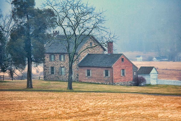
Historic Farmstead, Gettysburg National Battlefield, Gettysburg, Pennsylvania
Continuing on South Confederate Avenue, and after you pass the trail head for Big Round Top, take a right turn onto Wright Avenue and continue through the woods until you hit the open fields along Route 134 (Taneytown road). Drive slowly and be observant of the large confers to your left as they may hold a perching and resting raptor scoping out the open field to the right for an easy meal. We found a beautiful and uncommon Rough-legged Hawk sitting just inside the pines. I just caught a glimpse of this majestic bird out of the corner of my eye and couldn’t stop and get the camera up in time before he flushed and flew across the field to perch in distant tree.
This same bird it seems had been perched across the highway on Howe Avenue and Eric managed to get a shot or two before it made another retreat. Crossing Route 134 Wright Avenue turns into Howe Avenue, another favorite place of mine to photograph avian subjects. To the left as you drive eastward on Howe Avenue is a large and thick stand of cedars and other young trees. This area is of special interest to me because just a few evenings back, I had stopped there for a moment and heard the solitary hoot of a Long-eared owl, a very difficult bird to find due to their preference to be ”in the thick of things”. Earlier in the day I had observed about 20 Cedar Waxwings frolicking in the outlying young trees of the stand of cedars. This location is ideal habitat for the Long-eared owl due to the cover for concealment and then access to the open field across the small road for hunting. The Howe Avenue area receives very little traffic and is a nice place to spend a little time.


Been traveling and now home and getting caught up on email…glad I did not miss the one to this blog article. Great images as always and very informative of some of the places you visit. I need to visit some of these locations. Thank you Jim, and hope you have great new year.
Great shots and the Ring Necked Pheasant is really sweet.
Best Wishes Jim.
Bill